
 The historical significance of Winchester, Virginia cannot be overstated. Many battles of the Revolutionary War and Civil War occurred in and around Winchester with it’s highly coveted “roadways”, at least what roadways were back in those times. Those included here are not nearly everything, but certainly will give you a great flavor for the historical aspects of Winchester.
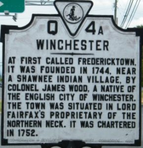
WINCHESTER: Starting with the historical marker for Winchester, Virginia itself, its inscription reads, “At first called Frederickstown, it was founded in 1744, near a Shawnee Indian village, by Colonel James Wood, a native of the English City of Winchester. The town was situated in Lord Fairfax’s proprietary of the northern neck. It was chartered in 1752.”
It is located in Winchester, Virginia on 1017 Millwood Pike (Route 50), approximate 100 yards east of the intersection with Front Royal Pike (Route 522). NOTE: The back side of this marker is inscribed with information about General Daniel Morgan and is featured later in this post.
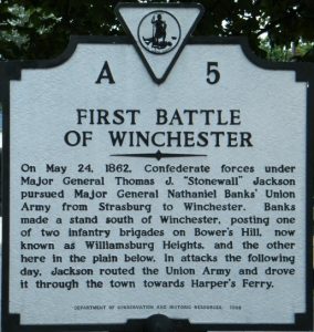 THE FIRST BATTLE OF WINCHESTER: Several such markers are around Winchester citing significant events of the Civil War. Marker A-5 has an inscription that reads, “On May 24, 1862, Confederate forces under Major General Thomas J. “Stonewall” Jackson pursued Major General Nathaniel Banks’ Union Army from Strasburg to Winchester. Banks made a stand south of Winchester, posting one of two infantry brigades on Bower’s Hill, now known as Williamsburg Heights, and the other here in the plain below. In attacks the following day, Jackson routed the Union Army and drove it through the town towards Harper’s Ferry.”
It is located in Winchester, Virginia on 1114 Valley Avenue and the marker will be on the left as you travel south. It faces parallel to the roadway.
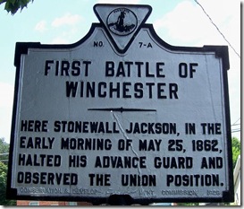
Marker A-7 has an inscription that reads, “Here Stonewall Jackson, in the early morning of May 25, 1862, halted his advance guard and observed the Union position.”
It is located at 2120 Valley Avenue (Route 11) and will be on the right if traveling north on Valley Avenue. Again, the marker is parallel with the roadway just past the Burger King.
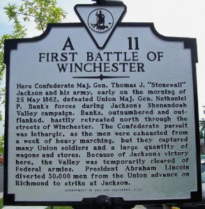
Marker A-11 is a short novel. Its inscription reads, “Here Confederate Maj. Gen. Thomas J. “Stonewall” Jackson and his army, early on the morning of 25 May 1862, defeated Union Maj. Gen. Nathaniel P. Bank’s forces during Jackson’s Shenandoah Valley campaign. Banks, outnumbered and outflanked, hastily retreated north through the streets of Winchester. The Confederate pursuit was lethargic, as the men were exhausted from a week of heavy marching, but they captured many Union soldiers and a heavy quantity of wagons and stores. President Abraham Lincoln diverted 30,000 men from the Union advance on Richmond to strike at Jackson.”
It is located just south of Winchester, Virginia on the west side of the Valley Pike (Route 11) approximately .2 miles south of the interchange with Route 37.
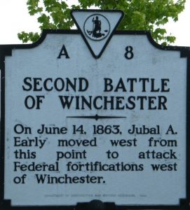 THE SECOND BATTLE OF WINCHESTER: This battle offers a few more historical markers beginning with A-8. Its inscription reads, “On June 14, 1863, Jubal A. Early moved west from this point to attack Federal fortifications west of Winchester.”
It’s is located very close to the marker for the First Battle of Winchester, A-11, just south of Winchester, Virginia on the west side of the Valley Pike (Route 11) approximately .2 miles south of the interchange with Route 37. 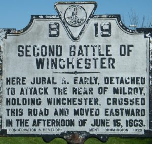
Marker B-19 has an inscription that reads, “Here, Jubal A. Early detached to attack the rear of Milroy, holding Winchester, crossed this road and moved eastward in the afternoon of June 15, 1863.
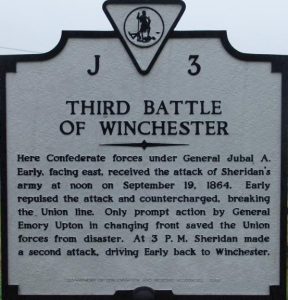 THE THIRD BATTLE OF WINCHESTER: Historical marker J-3 has an inscription that reads, “Here Confederates forces under Jubal A. Early, facing east, received the attack of Sheridan’s army at noon on September 19, 1864. Early repulsed the attack and countercharged, breaking the Union line. Only prompt action by General Emory Upton in changing front saved the Union forces from disaster. At 3 P.M. Sheridan made a second attack, driving Early back to Winchester.”
It is located east of Winchester on the south side of Berryville Pike (Route 7) just east of the intersection with Greenwood Road.
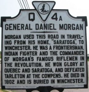
GENERAL DANIEL MORGAN: The “other side” of the Q4-A marker that identifies Winchester, this side’s inscription reads, “Morgan used this road in traveling from his home, “Saratoga,” to Winchester. He was a frontiersman, Indian fighter and the commander of Morgan’s famous riflemen in the Revolution. He won glory at Quebec and Saratoga, and defeated Tarleton at the Cowpens. He died in 1802 and is buried in Winchester.”
It is located in Winchester, Virginia on 1017 Millwood Pike (Route 50), approximate 100 yards east of the intersection with Front Royal Pike (Route 522). NOTE: The front side of this marker is inscribed with information about Winchester and is featured to open this post.
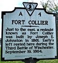 FORT COLLIER: The Fort Collier inscription reads, “Just to the east, a redoubt known as Fort Collier was built by Joseph E. Johnston in 1861. Early’s left rested here during the Third Battle of Winchester, September 19, 1864.”
This marker stands side-by-side with Q4-C which highlights George Washington and is featured later in this post. Side-by side State of Virginia historical markers show rich history found in Winchester. One talks about fort built for the Civil War which was involved in the 1864 Third Battle of Winchester (Fort Collier). The second tells about George Washington and his long relationship with Winchester, including the building of Fort Loudoun and the establishment of his first headquarters here.
These is located on the west side of U.S. 11, just north of the intersection with Brooke Road, across the street from the Fort Collier site.
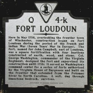 FORT LOUDOUN: The inscription for Fort Loudoun reads, “Here in May 1756, overlooking the frontier town of Winchester, construction began on Fort Loudoun during the period of the French and Indian War (Seven Year’s War in Europe). The fort, named for John Campbell, earl of Loudoun, was a square fortification with four bastions constructed of earth, wood, and stone. Col. George Washington, commander of the Virginia Regiment, designed the fort and supervised its construction until 1756. It served as Washington’s command center for a series of forts authorized by the Virginia House of Burgesses and built on the frontier that extended from the Potomac River to North Carolina. A well, dug through limestone bedrock, survives.”
It is located at the intersection of Loudoun Street and Peyton Street approximately 200 feet north of the intersection, near 419 Loudoun Street, Winchester, Virginia.
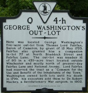 GEORGE WASHINGTON’S OUT-LOT: One of several Washington-related historical markers, this inscription reads, “Here was located George Washington’s five-acre out-lot from Thomas Lord Fairfax, Baron of Cameron, by grant of 15 May 1753. Fairfax also granted him a companion in-lot 77 at North Braddock Street and Fairfax Lane. The out-lot was number 16 of 80 in a 439-acre tract located outside Winchester and mostly north of present-day Fairfax Lane and National Avenue. Lord Fairfax had reserved the tract as a “Common for the Use and Benefit of the Inhabitants of the Town.” Washington owned both lots until his death in 1799; his executors sold them to Dr. Robert Mackey, a Revolutionary War surgeon, in 1805.”
It is located at the intersection of National Avenue (Route 7) and North Pleasant Valley Road. It will be on the right side when traveling west on National Avenue and is approximately 50 feet west of the intersection of Pleasant Valley Road and National Avenue.
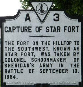 CAPTURE OF STAR FORT: The inscription reads, “The fort on the hilltop to the southwest, known as Star Fort, was taken by Colonel Schoonmaker of Sheridan’s Army in the Battle of September 19, 1864.”
Three times during the Civil War, Star Fort played a major role in the defense of Winchester during all three battles of Winchester.
It is located on Valley Turnpike (Route 11), on the right when traveling south, just south of the intercharge with Route 37 heading into downtown Winchester.
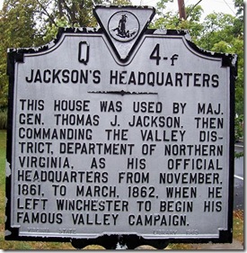 JACKSON’S HEADQUARTERS: The inscription reads, “This house was used by Maj. Gen. Thomas J. Jackson, then commanding the Valley District, Department of Northern Virginia. As his official headquarters from November, 1861, to March, 1862, when he left Winchester to begin his famous valley campaign.”
Both the house which served as Jackson’s headquarters and markers are on the west side of North Braddock Street just north of Peyton Street.
Alta Vista, the headquarters of Confederate General Thomas J. Jackson on the north side of Winchester, Virginia, is the home to Stonewall Jackson’s Headquarters Museum. It is marked by two historical markers on the street, and has been designated both a Virginia and a National Historic Landmark.
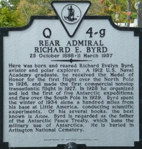 REAR ADMIRAL RICHARD E. BYRD: This inscription reads, “Here was born and reared Richard Evelyn Byrd, aviator and polar explorer. A 1912 U.S. Navy Academy graduate, he received the Medal of Honor for the first flight over the North Pole in 1926, and made the first commercial nonstop transatlantic flight in 1927. In 1928 he organized and led the first of five Antarctic expeditions, and flew over the South Pole in 1929. Byrd spent the winter of 1934 along a hundred miles from his base at Little America, conducting scientific experiments. Of his several books, the best known is Alone. Byrd is regarded as the father of the Antarctic Peace Treaty, which bans the military use of Antarctica. He is buried in Arlington National Cemetery.”
It is located at Boscawen Street and Amherst Street in Winchester, Virginia.
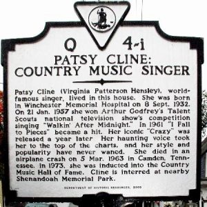 PATSY CLINE, COUNTRY MUSIC SINGER: Winchester’s favorite daughter, the famous Patsy Cline’s historical marker reads, “Patsy Cline (Virginia Patterson Hensley), world-famous singer, lived in this house. She was born in Winchester Memorial Hospital on 8 Sept. 1932. On 21 Jan. 1957 she won Arthur Godfrey’s Talent Scouts national television show’s competition singing “Walkin’ After Midnight.” in 1961 “I Fall to Pieces” became a hit. Her iconic “Crazy” was released a year later. Her haunting voice took her to the top of the charts, and her style and popularity have never waned. She died in an airplane crash on 5 Mar. 1963 in Camden, Tennessee. In 1973 she was inducted into the Country Music Hall of Fame. Cline is interred at nearby Shenandoah Memorial Park.”
This marker is located directly in front of Patsy Cline’s childhood home in Winchester, now a museum to the artist. The Patsy Cline House at 608 South Kent Street, in a working-class neighborhood of Winchester, Virginia was her home from 1948 to 1953. She moved out of the house when she got married at the age of 21 to Gerald Cline. The house was placed on both the Virginia Landmarks Register and the National Register of Historic Places in 2005 and a Virginia State Historical Marker was placed there about the same time.
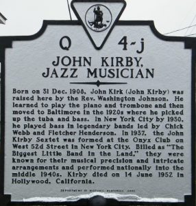 JOHN KIRBY, JAZZ MUSICIAN: The inscription reads, “Born on 31 Dec. 1908, John Kirck (John Kirby) was raised her by the Rev. Washington Johnson. He learned to play the piano and trombone and then moved to Baltimore in the 1920s where he picked up the tuba and bass. In New York City by 1930, he played bass in legendary bands led by Chick Webb and Fletcher Henderson. In 1937, the John Kirby Sextet was formed in the Onyx Club on West 52nd Street in New York City. Billed as “The Biggest Little Band in the Land,” they were known for their musical precision and intricate arrangements and performed nationally into the middle 1940s. Kirby died on 14 June 1952 in Hollywood, California.”
It is located on 508 North Kent Street in Winchester, Virginia. The marker will be on the right as you are traveling north on North Kent Street.
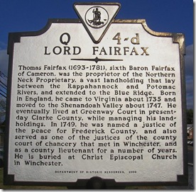 LORD FAIRFAX: This inscription reads, “Thomas Fairfax (1693-1781), sixth Baron Fairfax of Cameron, was the proprietor of the Northern Neck Proprietary, a vast landholding that lay between the Rappahannock and Potomac Rivers, and extended to the Blue Ridge. Born in England, he came to Virginia about 1735 and moved to the Shenandoah Valley about 1747. He eventually lived at Greenway Court in present-day Clarke County, while managing his landholdings. In 1749, he was named a justice of the peace for Frederick County, and also served as one of the justices on the county court of chancery that met in Winchester, and as a county lieutenant for a number of years. He is buried at Christ Episcopal Church in Winchester.”
It is located 1177 to 1199 North Frederick Pike (Route 522) approximately .8 miles southeast of the Route 37 interchange. The marker will be on the right side when traveling south on Route 522.